Monday 30 June 2014

30 Jun 2014. <GB-NIR> Giant's Causeway, & Ballintoy, & Balleymoney, & Ballypatrick Forest, Co. Antrim —
Woke up in our layby, and got ready for an early start. No such luck! Somehow the lights had been left on for part of the night, and the battery was flat. A call to the RAC (fortunately, in Northern Ireland, our UK phones now work again), and about an hour later a very friendly roadside assistance man arrived. All we needed was the jump start, but of course he checked everything for us, and we had the usual long conversation — Northern Irelanders are no different from their southern cousins, much to our delight! A note for other travellers — make sure your RACQ (RACV, NRMA) membership is up to date — the reciprocal agreement they have with RAC and other motoring organizations has proved most useful for us!


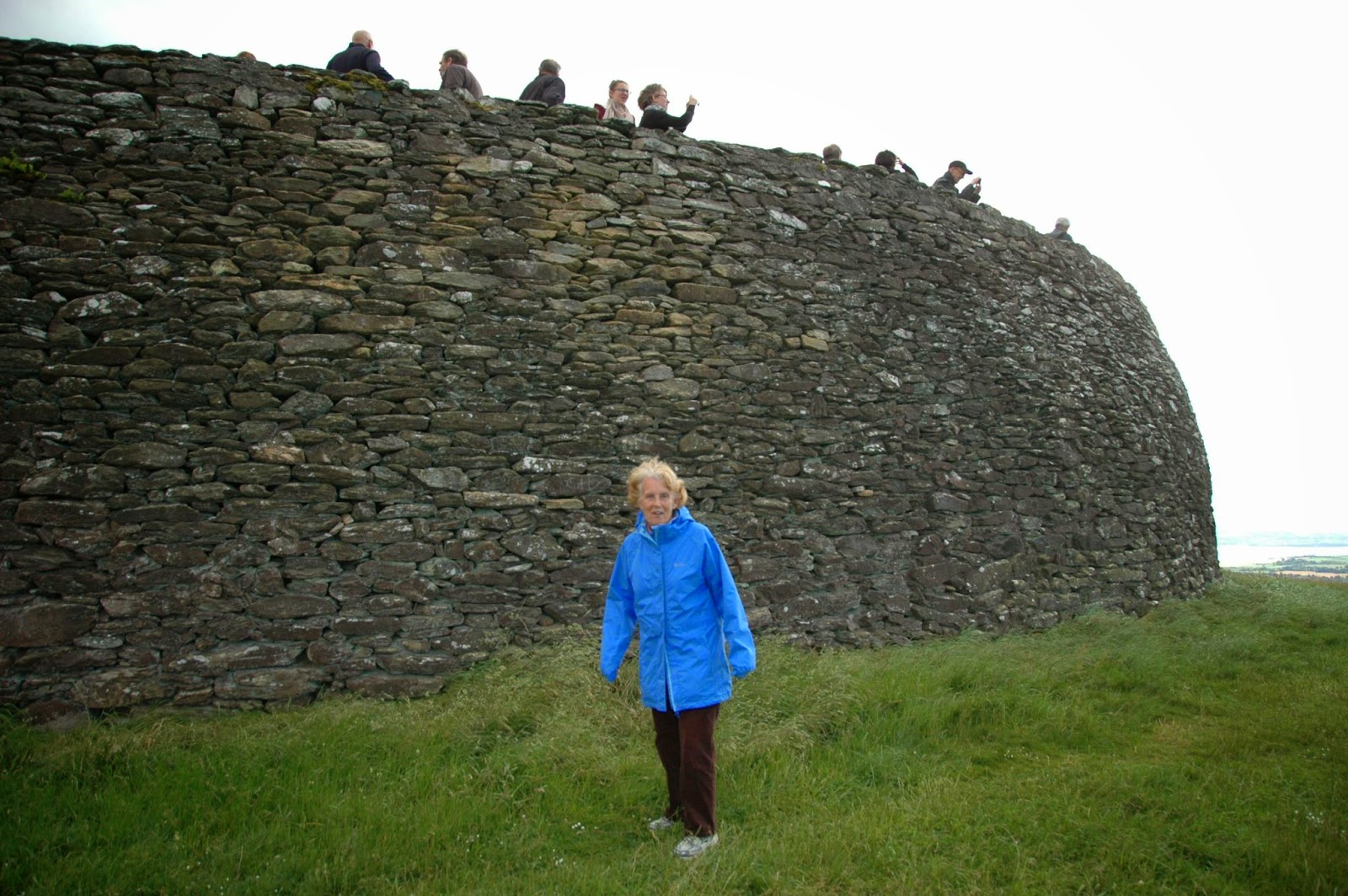
The Giant's Causeway


Susie on the Giant's Causeway
At 10.30 we set off for the Giant's Causeway again, getting there by 11am. This time we walked down (after picking up tickets and audio guides again), taking our time to enjoy the walk. We found various named features, like the Camel, and Finn's Granny, and explored right round to the next point — quite a substantial walk, but not difficult. (Many of the named features relate to the myth of the Irish Giant, Finn MacCool, who built a causeway from Ulster to Scotland to allow him to challenge his enemies the Scottish Giants, but when he realised that Benandonner was much larger than him, he retreated to Ulster, tearing up most of the causeway on his way back.) We then walked back, and this time took the bus back up to the Visitors Centre, where Susie was able to buy some postcards and stamps, and we had scones and coffee. We also checked how to get to the Dark Hedges, for later in the day.


Path round to the next point

Rathlin Island and Larrybane Headland at Carrick-a-Rede
(Larrybane is The Stormlands in Game of Thrones


Susie on the rope bridge

Warren on the rope bridge

Two birds on Carrick-a-Rede
Next destination (also a National Trust site) Carrick-a-Rede. This is about 7 miles further round the coast, and is a small island which was right in the salmon run. Fishermen have been crossing to the island via rope bridge for over 250 years, but now it's the turn of the tourists. The rope bridge is well constructed, spanning 20 metres, about 30 metres above the sea below. Susie and I had no troubles crossing it (the attendant said that Aussies seldom have difficulty, as they are descended from people who survived walking the gangplanks of the transportation ships!). A couple of people reneged at the last minute, but there's little to worry about! Our suggestion for anyone who is contemplating the same experience is to pack a picnic lunch — once you get across onto the island it is just crying out for you to find a place to spread a blanket and picnic! Just don't make it too bulky, as there is a 1km walk, involving 182 steps, on the way in — and obviously on the way back. But the views, again, are spectacular!

Next stop, the Dark Hedges. This will mean nothing to anyone who hasn't been watching Game of Thrones, but there is a road, Bregagh Road, in Ballymoney, County Antrim (just opposite the Gracehill Golf Club) which has the most incredibly sinuous trees interlocking over the road. These were used as the location for the King's Road in the aforesaid series. Even without the special attention to lighting given by the producers, this is a most eerie place to be. And, for a simple country road, the number of tourists wandering up and down was quite impressive — there were English, Irish, Italian, Japanese — and a couple of Aussies.


Our park for the night
Anyway, by now Susie and I wanted to settle down and get on with typing/writing/whatever. We decided to push out towards the coast, towards Cushendun, hoping to find a good viewing point on the way. We didn't make it — Susie spotted a picnic place in a forest, the Ballypatrick Forest, which was pretty deserted. It was deserted because the trails through the forest, normally open for drivers or walkers, are currently closed for harvesting operations. Which leaves the place pretty much to us! We anticipate a very quiet night!

Distance driven — today, 45 miles ( 73 km ); to date, 3,424 miles ( 5,511 km )

Sunday 29 June 2014

29 Jun 2014. <GB-NIR> Derry, Co. Londonderry; Magheracross, Co. Fermanagh; Giant's Causeway, Co. Antrim —

The Guild Hall on the way in
Woke up in our picnic area south of Derry. Got moving and into our carpark at the Railway Museum (as was). Went in to the town, via the Shipquay Gate. As it was just on 10am, the Tower Museum was just opening. We went in and went round, first, the display on the history of Derry. It put everything into perspective. After doing the city history, we went round their Spanish Armada exhibition, which went through the discovery, the archaeology, and the history of a Spanish ship, La Trinidad Valencera, discovered fairly recently off the coast near Derry. We spent abut 90 minutes in the museum, which could have been longer, but for serious hunger pangs overtaking the two of us.

We went into the centre of the city. Sunday morning, virtually everything closed and shuttered (except food outlets, fortunately). Maybe they were all down at the quays, where there was to be a parade of the Clipper Race competitors prior to their going out past Greencastle and Magilligan Point to start racing in earnest. Went into a Sandwich Bar (so named) and had a lovely morning tea to the sounds of a cocktail pianist playing one old standard after another. Very enjoyable.


Susie
at the Bloody Sunday Memorial

Free Derry Corner

Bogside Mural
The Petrol Bomber
Went out of the walled part of the city and down to Bogside, where a lot of the events during the Troubles took place. There are memorials all over the place, and a series of 12 murals — we showed you one yesterday — painted between 1994 and 2006 by Tom Kelly, Kevin Hasson and William Kelly. Justifiably famous, they make very strong comment about the plight of the Catholics of Bogside and their treatment by the British — particularly the paratroopers — from the garrison of the walled city.


We then decided to leave Derry and go on to the Giant's Causeway. It was a lovely sunny day by now, a Sunday, and there was to be an aerial display by the Red Arrows over Greencastle and Magilligan Point (as the Clipper Race got under way). Everybody and his dog was on the road out to this event — and it just happened that this was the road we needed to take! 4mph for at least half an hour (it seemed like an eternity!). But we finally got off onto an alternative route and made good progress.

We stopped off at a viewing point, Magheracross, just past Portrush, with superb views back to Portrush, across the Skerries, and round to the Giant's Causeway — and even across to Scotland. Another place to revisit tomorrow.

We got to the Giant's Causeway site at about 5.30pm, and the sun was in a superb position for viewing. It would have cost us £8.50 each, but we decided to bite the bullet and join the National Trust, a joint membership being £95 per annum, and then all National Trust properties are free to visit (and park at!). Put that with our English Heritage membership, and we have a free pass into a huge number of sites. It will pay for itself in a very short time! Went down to the Giant's Causeway (took the bus down and back to save time, although missing out on part of the magic — the bus is free to Trust members, £1 each way for others). Spent about 45 minutes down there, and made the resolution to return on the morrow to do the place justice.


Distance driven — today, 76 miles ( 122 km ); to date, 3,379 miles ( 5,438 km )

Saturday 28 June 2014

28 Jun 2014. <GB-NIR> Derry, Co. Londonderry —
Happy Birthday Jonathan!

The birds woke us in the picnic area on the banks of the Foyle, close to Derry. Our plan to go in and park at the Railway Museum worked like a charm, and we were soon walking into the city. Just a block or so from our park, on the way in, was the Derry Visitor and Convention Bureau, a very big information area — it's obvious that Derry puts a lot of effort into tourism! The smiles on the girls at the Information Centre were reason enough to attract tourists to the place — a very warm welcome to the city. And outside there were people offering walking tours of the city. But you know us — independence personified. Give us a map, and perhaps a guidebook, and we'll take ourselves around. And that's what we did.


Gun on City Wall

Guns at Wall of Derry
Derry is the only fully walled city in Ireland, and the walls themselves are incredible. They were completed in 1618, and are 30 feet thick in parts — which makes for a wide boulevarde to walk around the top of the walls, and around the whole medieval part of the city. There were originally four gates (there are now five). It's rather intimidating to walk outside the wall near Artillery Street and see the wall bristling with cannon! The city's walls have never been breached, and the city has never surrendered when under siege, although it has been a close-run thing. This is why Derry is sometimes called "the Maiden City".


Bogside Mural
On the houses on the Bogside (where the Irish, as opposed to the British, lived) there are some murals painted by the "Bogside Artists", specifically to get under the noses of the Brits. The one shown here is of a schoolgirl who was shot by a British Soldier while she was picking up stones on the roadside for a school project! Anyway, we walked the walls for about an hour, then went back to the van to pick up our jackets — the wind was a little cool, and we were going to walk across the Peace Bridge, which would be somewhat exposed.

Peace Bridge


Warren on Peace Bridge
We came back to the Guild Hall, and went in to the cafe there — we were told by a woman at the next table that this was the best cafe in Derry — and one of the cheapest! Well, the food was good, the coffee hot, and we enjoyed our time there. Then we left for the Peace Bridge, which crosses the Foyle just near the Guild Hall. This footbridge, linking the two sides of the River Foyle, and which symbolically links the two sides of the "Troubles" that have plagued Northern Ireland for so many years, was only opened three years ago. It is a suspension bridge, but suspended from two angled towers which means that the bridge takes a sinuous path across the river. Quite spectacular. And there were some interesting shots of the city from the other side, once we got there.


Clipper Race Yachts


Tall Ships

Kids having fun
We have been making a habit of turning up in the right place at the right time. Today is no exception. The boats from the Clipper Round the World 13-14 Race are in port, and the 15th leg of the race sets off from here tomorrow. There are two tall ships in port, as is the RN Frigate LÉ Róisín, and they are all allowing people on board. We went onto the Phoenix, a tall barque-rigged ship which ties in to our Doctor Who viewing, as it was used in the 2011 series! It has also appeared in numerous feature films and other TV series! This is all part of the LegenDerry Maritime Festival, which is running from June 21-29. This afternoon, the sun came out, and the waterfront was alive! We're having a ball!


Distance driven — today, 11 miles ( 18 km ); to date, 3,303 miles ( 5,316 km )

Friday 27 June 2014

27 Jun 2014. <IE> Monaghan, Co. Monaghan; <GB-NIR> Omagh, Co. Tyrone; Derry, Co. Londonderry; <IE> Grianan of Aileach, Co. Donegal —
Happy birthday Warren! Woke up on the banks of the Boyne in Slane. The day looked a little dubious, so we decided not to go back up to the Hill of Slane (as we had been half considering doing), but instead to push on northwards. It was a good day for driving, with intermittent showers, so that's what we did.

We drove north up the N2 through Monaghan (Muineachan), and in so doing drove through the only county of the Republic of Ireland that we had not yet visited. We kept on northwards, and the N2 became the A5 — we were now in Northern Ireland, and back in the UK. Miles per hour, and pounds Sterling! We went up to Omagh, where we pulled in to a park and pay to get our bearings. Warren walked in to find the local Tourist Centre (this has become almost routine by now as our first stop in any town), and to ask for the location of a convenient launderette. Turns out it was an easy walk from our van, so we went round to see if they could fit our laundry in before the end of the day (it was by now after one pm). No worries, and the woman in the launderette showed us where we could park just outside to offload. So we went back to the van, sorted out what needed to be washed (making a HUGE bundle), then drove it round to her. It took a while to drop it off, as she, like many Irish, really wanted to talk!

We then took the van back to the park and ride, paid for three more hours (only £1, which by chance gave us to the following morning — not that we needed it!) We settled in to rest, but not before Warren celebrated with a birthday cake and a bottle of Guinness!

3.35pm came, and we returned to the launderette, where we picked up our laundry and, after another lengthy conversation, took our leave. Our next plan was to get to Londonderry (Derry), then back into the Republic to have a look at a nearby ring fort, Grianan Ailigh, near the village of Burt in County Donegal. On the way, just coming in towards Derry, we noticed a picnic area off the road just south of Prehen, about 3km south of Derry — a good option for tonight! And then, coming in towards Derry itself, Susie's shin started to cramp, so we needed to pull off fairly quickly. We crossed the River Foyle on the lower deck of the Craigavon Bridge and, instead of turning right and following the A2 north towards our intended destination, turned south to find a park and relief for Susie's shin. Just south of the bridge is/was the Foyle Valley Railway and Museum. It is closed down at the moment, but its car park has been left open for free public parking. We pulled in, and then thought that this would be an ideal base of operations for tomorrow!


Susie at Fort (+ Tourists!)
Anyway, Susie's shin recovered, and we drove on and out to the Grianán Ailigh. This is at the top of a rather steep hill (first gear all the way!) and, as we continued to climb, the view became better and better. This has to be one of the best views we have ever seen — it's absolutely magic. So, at the top, we got out and explored the ring fort (until a coachload of German tourists gushed out of a bus that miraculously got up that narrow road up that steep hill). We then sat in the van for at least half an hour and just enjoyed the view, a perfect ending to a wonderful birthday for Warren. when we finally came down, we drove to the picnic spot we mentioned before, and settled in for the night.

Distance driven — today, 138 miles ( 222 km ); to date, 3,292 miles ( 5,298 km )

Thursday 26 June 2014

26 Jun 2014. <IE> Dublin; Slane, Co. Meath —
Our last day in Dublin. We were going to leave first thing, but the weather was too good to waste. We went into town and went into the reading room of the National Library of Ireland. There's a beautiful ellipsoid dome, in shades of blue. Looked at the catalogue, and didn't recognise the format of the catalogue number, so went and asked what classification system was being used. The librarian, with some evidence of exasperation at the situation, said that they had used Dewey until some years ago, but now books are simply issued with an accession code, and are retrieved by that. I suppose that's okay if you have closed stacks (as is the case), but it makes it impossible to have those serendipidous discoveries you get by browsing the shelves, or computer browsing by call number, in a library with a good systematic classification system. Warren has been spoiled in working his whole library career in a library with good Library of Congress classification!

We spent some time in a Starbucks to let Warren catch up on the blog — we trust the time is well spent and all our friends and family in Oz are getting some feel of our travels! Thanks to all those people who have been making comments on the blog!


Henry Street & Spire

Fruit Vendor

GPO
We then went over to the north side of the Liffey to the pedestrian shopping areas of Mary Street / Henry Street / Earl Street North, which we had only sampled quickly yesterday because of the rain. This is a very lively shopping precinct, with buskers of an incredibly high standard, street vendors of fruits (using converted prams as their trolleys), people walking everywhere, and the whole overlooked by the Dublin Spire. We're glad we went back, as our first impression yesterday was of a wet and soggy place, not the lively place it really is!

Finally, we went back to the van and set off for points further north. Decided to set the Garmin to avoid tolls — there was one awkward section of the M50 around Dublin which has a toll, but the toll has to be paid in stores or online — this would have made for difficulty in our case, so we decided to avoid it. The Garmin took us on alternative roads, including the North Circular Road, and it took us within spitting distance of Kilmainham Gaol, so we knew where we were! We left Dublin on the N2, which took us up towards Slane (towards our ultimate destination of Derry).


Friary
When we got to Slane, we decided to pick up a few loose ends of our travels round the Boyne Valley. The statue of St Patrick on the Hill of Tara looks out towards the Hill of Slane, where St Patrick is traditionally said to have lit the Easter fire in 433, unwittingly disobeying King Laoghaire at Tara. The confrontation had a happy ending, however, as Laoghaire's druid, Erk, converted to Christianity (and later became the first Bishop of Slane), and the King was pacified. The Easter Fire is still lit each year on the Hill of Slane. So we went up to the Hill of Slane. The ruins of the Friary there date from 1512, so there is little connection with St Patrick — but it's rather nice just to visit the place!


We then went down to a car park Warren noticed on the way in to Slane, where the flat terrain will allow for a good night's sleep.

Distance driven — today, 40 miles ( 64 km ); to date, 3,154 miles ( 5,076 km )

Wednesday 25 June 2014

25 Jun 2014. <IE> Dublin —

Kilmainham Gaol - New Wing

Kilmainham Gaol
Old Wing
Corridor with
Easter Rising Cells
Went in to Dublin again this morning, but to different parts. Our first port of call was the Kilmainham Gaol. If you've seen the Daniel Day Lewis film "In the Name of the Father" you've seen part of the gaol, as some of the filming was done there. It has also featured in other movies! But the guided tour of the gaol was not as much a history of the gaol, but a history of the Irish rebellions, as many of the participants were imprisoned, and many executed, here. Ireland has had a sad history of suppression by the British, and our guide, for the best of reasons, had very strong sympathies with the Irish. For example, all seven signatories of the Proclamation of the Irish Republic, read from the steps of the Dublin GPO on Easter Monday, 1916, at the start of the Easter Rising, were executed by firing squad at Kilmainham Gaol.

De Vallera's Cell
The war of Independence effectively ended with the declaration of a truce in 1921, which set up the Irish Free State, but which left Ulster still in the hands of the British (as Northern Ireland), and which forced all of Ireland to still swear fealty to the British crown. A Civil War ensued, between those who accepted the truce and those who didn't. Later the gaol was used as a prison during the Civil War (1922-24), by the Free State Army to imprison those who rebelled against the truce. The Gaol's last prisoner, at the end of the Civil War, was Éamon De Valera, who later became Taioseach (Prime Minister) and then President of Ireland. A lot of violent history, very recent, and very much involving Kilmainham Gaol.


We next went to the National Museum of Decorative Arts and History in the Collins Barracks on Benburb Street. Tying in with our earlier explorations, the property was originally granted to the 12th Duke of Ormond for him to build on it a palace and gardens. This was never done, however, and his grandson sold the property to the Government in 1704, and it was developed into a military barracks which, until 1922, were used as the British Army headquarters in Ireland, and from then it housed units of the Irish Army until 1994, when the Government decided to develop it into a museum. We went through its current exhibition of 1916 Rising history, as it tied in well with our earlier activities of the day.

We then went to the Jameson Distillery in the hope of getting to the top of its old smokestack for a good look around Dublin. Sadly, the property with the smokestack was sold off about 7 years ago, and the hotel that now owns it has closed down the lifts that operated up the outside of the smokestack. C'est la vie!


Spire of Dublin

Parnell Monument
We went in to O'Connell Street in town, just a short way east of where we were, and just north of where we were yesterday. Walked up to the Spire, now the symbol of Dublin. It is a spike — can't call it much else — 120m high, 3m in diameter at the base, tapering up to 15cm at the top. It's in O'Connell Street diagonally in front of the GPO, the site of the siege of the 1916 Easter Rising (and which still shows evidence of bullet holes from those days). A block north is the Parnell Monument, and a block further is the Garden of Remembrance.


It was starting to rain by now, so we adjourned to La Pizza in O'Connell Street for a pepperoni pizza washed down with coffee (Suzie) and wine (Warren). It was fun watching the tourists in the open-topped tour buses scattering for shelter. We then walked back down to Abbey Street, on the way looking quickly at Earl Street North, the start of the major shopping pedestrian precinct north of the River Liffey. After this, we decided to call it a day, and went back to our van. We wanted to do a little clothing shopping at Dunnes before settling into our spot for the night.


Earl Street North

Distance driven — today, 3 miles ( 5 km ); to date, 3,114 miles ( 5,012 km )

Tuesday 24 June 2014

24 Jun 2014. <IE> Dublin —
Went in to Dublin. Dropped in to Trinity College to ask the student guides where they went to buy their stationery. When they said "Eason's, in Nassau Street" (very conveniently close to the College!), we went down there to look for the books Susie has started keeping her journals in. They had some on a display on the ground floor but, when we asked, they pointed us towards more in the basement. Susie was in seventh heaven! She now has enough books to write up the rest of this year, and then some!! We left our purchases at the store while we went off exploring!


Museum Foyer

Inside the Museum
Went down to the National Museum of Ireland - Archaeology, which had been closed yesterday, but was open and welcoming today. Not only were we able to explore the Neolithic and later periods of Ireland's history, the periods we had been dipping into as we wandered Ireland, and to see the Chalice of Armagh and the Brooch of Tara, but they had a special exhibition on the Battle of Clontarf (Cluain Tarbh), which took place in 1014, a thousand years ago. The first High King of Ireland, Brian Boru, fought in this battle against the Vikings for the possession of Dublin and its surrounding region. Although the Irish were victorious, Brian was slain in the battle. So important was Brian Boru in the history of Ireland and its psyche that the harp which you see everywhere as the official symbol of Ireland is the one attributed to Brian Boru himself, and we saw a replica of it in the Long Room of the Old Library at Trinity College yesterday. What people don't usually realise about the Battle of Clontarf was not that Brian Boru wished to evict the Vikings from Ireland, he just wanted to set up more favorable trading relations with them, but the Vikings were not amenable to such dealings.

Armagh Chalice

Tara Brooch

After spending about 3 hours in the Museum, we went for a delightful meal in its cafeteria — Susie had scones, jam and cream with her coffee (what else?), but Warren this time opted for cottage pie for a change.


Oscar Wilde Monument
We then went further east to try to find the Powerscourt Tower, for the Museum of Irish Dance. Well, we found Powers Court, but that had nothing to do with the place. Apparently the Powerscourt Centre is off Grafton Street, the pedestrian area we were in yesterday. So we started back. On the way, we went through Merrion Square, another fine park. This one has the honour of having had Oscar Wilde's dwelling at its northwest corner. The house is at Number One Merrion Square, now occupied and maintained by the American College Dublin, and in the park there is a memorial to Oscar Wilde at that point in the park. The park itself differs from the others we had visited in that it is more heavily wooded, although it still has open grassed areas for lying out and sunning yourself, which was certainly in order today!

Further on our walk back to the main drag we happened on the National Gallery of Ireland. Popped in for a short commune with the old masters. Noticed a lovely Vermeer that we're sure our friend Cathy Jones would appreciate!

After afternoon coffee, we continued on (picking up our shopping from Eason's on the way) into Grafton Street, and behind it to Clarendon Street, where we finally found the Powerscourt Centre and the Museum of Irish Dance — CLOSED!! It opens again for its next live show, next Saturday at 6pm. Unfortunately, we'll be in parts further north by then!

At this point, we decided to call it a day and adjourned to the van for tea, Macca's for internet time, then back to the Clondalkin Park and Ride to overnight.

Distance driven — today, 3 miles ( 5 km ); to date, 3,111 miles ( 5,007 km )